Our website is made possible by displaying online advertisements to our visitors.
Please consider supporting us by disabling your ad blocker.
Ailinglaplap
| Ailinglaplap | ||
|---|---|---|
 | ||
| Gewässer | Pazifischer Ozean | |
| Archipel | Marshallinseln | |
| Geographische Lage | 7° 31′ N, 168° 44′ O | |
|
| ||
| Anzahl der Inseln | 56 | |
| Hauptinsel | Bikar | |
| Landfläche | 14,69 km² | |
| Lagunenfläche | 750,29 km² | |
| Einwohner | 1175 (2021) | |
 | ||
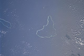
Ailinglaplap (deutsch veraltet: Lambertinseln, Odia;[1] auch: Ailinglapalap) ist ein Atoll der Ralik-Kette der Marshallinseln. Das Atoll hat eine dreieckige Form von 43 km Länge und maximal 30 km Breite. Australien liegt etwa 3500 km von Ailinglaplap entfernt. Die bedeutendsten Inseln des Atolls sind Airuk, Beran, Bikar, Buoj, Enewe, Ennak, Jabwan, Jeh, Kattiej, Mejajok, Mejil, Tobomaro und Woja. Auf dem Atoll leben 1175 Bewohner (Stand 2021).[2]
- ↑ Heinrich Schnee (Hrsg.): Deutsches Koloniallexikon. 3 Bände, Quelle & Meyer, Leipzig 1920.
- ↑ Republic of the Marshall Islands 2021 Census Report. Band 1: Basic Tables and Administrative Report. Secretariat of the Pacific Community, 2023, Table 3: Population by Urban/Rural and atoll by sex, S. 10 (englisch, sdd.spc.int [PDF; 3,9 MB; abgerufen am 16. Juni 2024]).
Previous Page Next Page


