Our website is made possible by displaying online advertisements to our visitors.
Please consider supporting us by disabling your ad blocker.
Ceredigion
| Ceredigion | ||||
|---|---|---|---|---|
| Autoridad unitaria | ||||
 | ||||
|
Lema: Golud • Gwlad • Rhyddid («La opulencia de una nación es su Libertad») | ||||
 | ||||
| Coordenadas | 52°15′10″N 4°00′01″O / 52.252777777778, -4.0002777777778 | |||
| Capital | Aberystwyth y Aberaeron | |||
| Entidad | Autoridad unitaria | |||
| • País |
| |||
| • Nación |
| |||
| • Región | Canolbarth Cymru | |||
| • Subregión | Oeste de Gales | |||
| Superficie | Puesto 4.º | |||
| • Total | 1783 km² | |||
| Población (2018) | Puesto 4.º | |||
| • Total | 72 992 hab. | |||
| • Densidad | 41 hab./km² | |||
| ISO 3166-2 | GB-CGN | |||
| Código ONS |
00NQ W06000008 (GSS) | |||
| NUTS 3 | UKL14 | |||
| Sitio web oficial | ||||
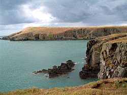
Ceredigion (ⓘ) es una autoridad unitaria situada en la Canolbarth Cymru (Región central), que a su vez pertenece a la subregión occidental de Gales (Gorllewin Cymru) en el Reino Unido.[1][2] Perteneciente a los condados históricos de Cardiganshire.
Limita al oriente con el condado de Powys, al sur con Carmarthenshire, al suroriente con Pembrokeshire y al norte con Gwynedd. Al occidente está bañado por el mar de Irlanda.
- ↑ Office for National Statistics (2009). «United Kingdom: Counties and Unitary Authorities» (en inglés). Consultado el 24 de febrero de 2013.
- ↑ Office for National Statistics. «Counties, Non-metropolitan Districts and Unitary Authorities» (en inglés). Consultado el 24 de febrero de 2013.
Previous Page Next Page


