Back كليركس (باد كاليه) Arabic كليركس ARZ Clerques AST Clerques BR Clerques Catalan КлегӀк CE Clerques CEB Clerques German Clerques DIQ Clerques Spanish
Clerques
Klarke | |
|---|---|
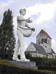
 The Sower and Saint-Barthélémy's church | |
| Coordinates: 50°47′37″N 1°59′43″E / 50.7936°N 1.9953°E | |
| Country | France |
| Region | Hauts-de-France |
| Department | Pas-de-Calais |
| Arrondissement | Saint-Omer |
| Canton | Lumbres |
| Intercommunality | Pays de Lumbres |
| Government | |
| • Mayor (2020–2026) | Aurélien Dommanget[1] |
Area 1 | 6.39 km2 (2.47 sq mi) |
| Population (2022)[2] | 314 |
| • Density | 49/km2 (130/sq mi) |
| Time zone | UTC+01:00 (CET) |
| • Summer (DST) | UTC+02:00 (CEST) |
| INSEE/Postal code | 62228 /62890 |
| Elevation | 37–173 m (121–568 ft) (avg. 47 m or 154 ft) |
| 1 French Land Register data, which excludes lakes, ponds, glaciers > 1 km2 (0.386 sq mi or 247 acres) and river estuaries. | |
Clerques (French pronunciation: [klɛʁk]; West Flemish: Klarke) is a commune in the Pas-de-Calais department in the Hauts-de-France region of France[3] 10 miles (16 km) northwest of Saint-Omer, in the valley of the river Hem at the foot of the Boulonnais, which is a wooded ridge there. Two hamlets, Audenfort to the west and Le Hamel to the east, make up the remainder of the commune.
- ^ "Répertoire national des élus: les maires" (in French). data.gouv.fr, Plateforme ouverte des données publiques françaises. 13 September 2022.
- ^ "Populations de référence 2022" (in French). The National Institute of Statistics and Economic Studies. 19 December 2024.
- ^ INSEE commune file


