Our website is made possible by displaying online advertisements to our visitors.
Please consider supporting us by disabling your ad blocker.
Eyserheide
Eyserheide
Ezerhei | |
|---|---|
Village | |
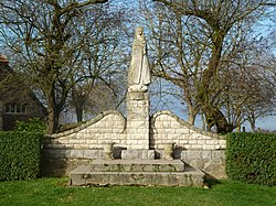
 Statue in Eyserheide | |
| Coordinates: 50°50′21″N 5°55′55″E / 50.839167°N 5.931944°E | |
| Country | |
| Province | |
| Municipality | |
| Area | |
• Total | 0.65 km2 (0.25 sq mi) |
| Elevation | 130 m (430 ft) |
| Population (2021)[1] | |
• Total | 125 |
| • Density | 190/km2 (500/sq mi) |
| Time zone | UTC+1 (CET) |
| • Summer (DST) | UTC+2 (CEST) |
| Postal code | 6285[1] |
| Dialing code | 043 |
Eyserheide (English: Eys heathland, Limburgish: Ezerhei) is a hamlet in the southeastern Netherlands. It is located close to the village of Eys in the municipality of Gulpen-Wittem, Limburg, around 15 km east of Maastricht.[3] The name refers to a former heathland in the area. The village has a population of 90 people.
Together with the neighboring hamlets of Elkenrade and Mingersberg, it is located on the plateau of Ubachsberg. The village is known for the Eyserbosweg, a steep hill to the south of the village which is part of the Amstel Gold Race.[4] To the west of the village is the forest Eyserbos.
- ^ a b c "Kerncijfers wijken en buurten 2021". Central Bureau of Statistics. Retrieved 24 April 2022.
- ^ "Postcodetool for 6285AA". Actueel Hoogtebestand Nederland (in Dutch). Het Waterschapshuis. Retrieved 24 April 2022.
- ^ Geen aardappelveld op Eyserheide Archived 2014-05-03 at the Wayback Machine, Dagblad de Limburger, 19 March 2011
- ^ Ploeteren op de Eyserbosweg Archived 2014-05-03 at the Wayback Machine, Nederlandse Omroep Stichting, 18 April 2010
Previous Page Next Page


