Our website is made possible by displaying online advertisements to our visitors.
Please consider supporting us by disabling your ad blocker.
Fangataufa
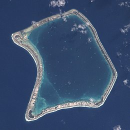
 Satellite view of Fangataufa Atoll showing the dark blue depths of the induced crater. Courtesy NASA. | |
| Geography | |
|---|---|
| Location | Pacific Ocean |
| Coordinates | 22°15′S 138°45′W / 22.250°S 138.750°W |
| Archipelago | Tuamotus |
| Area | 45 km2 (17 sq mi) (lagoon) 5 km2 (2 sq mi) (above water) |
| Length | 9.5 km (5.9 mi) |
| Width | 9.5 km (5.9 mi) |
| Administration | |
France | |
| Overseas collectivity | French Polynesia |
| Administrative subdivision | Tuamotus |
| Commune | Tureia |
| Demographics | |
| Population | Uninhabited[1] (2012) |
Fangataufa (or Fangatafoa) is an uninhabited coral atoll in the eastern part of the Tuamotu Archipelago in French Polynesia. The atoll has been fully-owned by the French state since 1964. From 1966 to 1996 it was used as a nuclear test site by the French government. In total, 4 atmospheric and 10 underground nuclear explosions were carried out on the atoll.
- ^ "Population". Institut de la statistique de la Polynésie française. Archived from the original on 11 April 2020. Retrieved 25 September 2014.
Previous Page Next Page


