Back فيرينج ARZ Fehring BS Феринг CE Fehring (munisipyo) CEB Fehring Czech Fehring German Fehring EO Fehring Spanish Fehring ET Fehring EU
Fehring | |
|---|---|
 | |
| Coordinates: 46°56′00″N 16°01′00″E / 46.93333°N 16.01667°E | |
| Country | Austria |
| State | Styria |
| District | Südoststeiermark |
| Government | |
| • Mayor | Johann Winkelmaier (ÖVP) |
| Area | |
• Total | 87.08 km2 (33.62 sq mi) |
| Elevation | 272 m (892 ft) |
| Population (2018-01-01)[2] | |
• Total | 7,284 |
| • Density | 84/km2 (220/sq mi) |
| Time zone | UTC+1 (CET) |
| • Summer (DST) | UTC+2 (CEST) |
| Postal code | 8350 |
| Area code | +43 3155 |
| Vehicle registration | FB |
| Website | www.fehring.at |


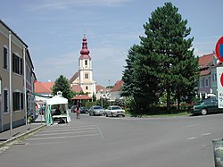
Fehring is a municipality in the district of Südoststeiermark in Styria, Austria.[3] The landscape is rolling hills cut by the valley of the Raab. Fehring is on a socket some metres above the valley floor. The town is bordered to the east by Burgenland.
- ^ "Dauersiedlungsraum der Gemeinden Politischen Bezirke und Bundesländer - Gebietsstand 1.1.2018". Statistics Austria. Retrieved 10 March 2019.
- ^ "Einwohnerzahl 1.1.2018 nach Gemeinden mit Status, Gebietsstand 1.1.2018". Statistics Austria. Retrieved 9 March 2019.
- ^ "Fehring (Austria) map - nona.net". nona.net. Retrieved 2024-02-08.

