Our website is made possible by displaying online advertisements to our visitors.
Please consider supporting us by disabling your ad blocker.
Flaxweiler
This article needs additional citations for verification. (February 2013) |
Flaxweiler
Fluessweiler (Luxembourgish) | |
|---|---|
 | |
 Map of Luxembourg with Flaxweiler highlighted in orange, and the canton in dark red | |
| Coordinates: 49°39′55″N 6°20′35″E / 49.6653°N 6.3431°E | |
| Country | |
| Canton | Grevenmacher |
| Government | |
| • Mayor | Paul Ruppert |
| Area | |
• Total | 30.17 km2 (11.65 sq mi) |
| • Rank | 26th of 100 |
| Highest elevation | 387 m (1,270 ft) |
| • Rank | 63rd of 100 |
| Lowest elevation | 208 m (682 ft) |
| • Rank | 28th of 100 |
| Population (2023) | |
• Total | 2,193 |
| • Rank | 70th of 100 |
| • Density | 73/km2 (190/sq mi) |
| • Rank | 79th of 100 |
| Time zone | UTC+1 (CET) |
| • Summer (DST) | UTC+2 (CEST) |
| LAU 2 | LU0001103 |
| Website | flaxweiler.lu |
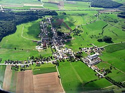
Flaxweiler (Luxembourgish: Fluessweiler) is a commune and small town in south-eastern Luxembourg. It is part of the canton of Grevenmacher.
As of 2024[update], the town of Flaxweiler, which lies in the north-west of the commune, has a population of 593.[1] Other towns within the commune include Beyren, Gostingen, Niederdonven, and Oberdonven.
- ^ "Registre national des personnes physiques RNPP : Population par localité". data.public.lu. 2024-01-07.
Previous Page Next Page


