Back Fréiseng ALS Фрызанж BE Фрызанж BE-X-OLD Frisange Catalan Frisange (munisipyo) CEB Frisange Danish Frisingen German فریسانژ FA Frisange French Frisange Italian
This article needs additional citations for verification. (January 2021) |
Frisange
| |
|---|---|
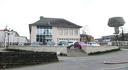
 Town hall | |
 Map of Luxembourg with Frisange highlighted in orange, and the canton in dark red | |
| Coordinates: 49°30′54″N 6°11′30″E / 49.515°N 6.19167°E | |
| Country | |
| Canton | Esch-sur-Alzette |
| Government | |
| • Mayor | Roger Beissel |
| Area | |
• Total | 18.43 km2 (7.12 sq mi) |
| • Rank | 63rd of 100 |
| Highest elevation | 293 m (961 ft) |
| • Rank | 100th of 100 |
| Lowest elevation | 224 m (735 ft) |
| • Rank | 37th of 100 |
| Population (2023) | |
• Total | 4,912 |
| • Rank | 33rd of 100 |
| • Density | 270/km2 (690/sq mi) |
| • Rank | 30th of 100 |
| Time zone | UTC+1 (CET) |
| • Summer (DST) | UTC+2 (CEST) |
| LAU 2 | LU0000205 |
| Website | frisange.lu |
Frisange (French pronunciation: [fʁizɑ̃ʒ]; Luxembourgish: Fréiseng, German: Frisingen) is a commune and town in southern Luxembourg. It is part of the canton of Esch-sur-Alzette.
As of 2024[update], the town of Frisange, which lies in the north of the commune, has a population of 2,388.[1] Other towns within the commune include Aspelt and Hellange.

- ^ "Registre national des personnes physiques RNPP : Population par localité". data.public.lu. 2024-01-07.
