Our website is made possible by displaying online advertisements to our visitors.
Please consider supporting us by disabling your ad blocker.
Karwendel
| Karwendel | |
|---|---|
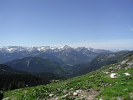
 View of the northeastern part of the Karwendel (Location: Blue Mountains) | |
| Highest point | |
| Peak | Birkkarspitze |
| Elevation | 2,749 m (9,019 ft) |
| Coordinates | 47°24′41″N 11°26′15″E / 47.41139°N 11.43750°E |
| Geography | |
 | |
| Countries |
|
| Range coordinates | 47°25′N 11°28′E / 47.417°N 11.467°E |
| Parent range | Northern Limestone Alps |
The Karwendel is the largest mountain range of the Northern Limestone Alps. It is located on the Austria–Germany border. The major part belongs to the Austrian federal state of Tyrol, while the adjacent area in the north is part of Bavaria, Germany. Four chains stretch from west to east; in addition, there are a number of fringe ranges and an extensive promontory (Vorkarwendel) in the north.
Previous Page Next Page


