Back Katiu AZ Katiu Catalan Katiu Atoll CEB Katiu German Katiu EO Katiu (atolón) Spanish Katiu French Atol Katiu GL Katiu Hungarian Katiu Italian
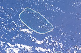
 NASA picture of Katiu Atoll | |
| Geography | |
|---|---|
| Location | Pacific Ocean |
| Coordinates | 16°25′S 144°22′W / 16.417°S 144.367°W |
| Archipelago | Tuamotus |
| Area | 232.5 km2 (89.8 sq mi) (lagoon) 10 km2 (4 sq mi) (above water) |
| Length | 27 km (16.8 mi) |
| Width | 12.5 km (7.77 mi) |
| Administration | |
France | |
| Overseas collectivity | French Polynesia |
| Administrative subdivision | Tuamotus |
| Commune | Makemo |
| Largest settlement | Toini |
| Demographics | |
| Population | 257[1] (2022) |

Katiu, or Taungataki,[2] is an atoll of the central Tuamotu Archipelago in French Polynesia. It is located 23.5 kilometres (14.6 miles) west of Makemo Atoll's westernmost point. It measures 27 kilometres (17 miles) in length with a maximum width of 12.5 kilometres (7.8 miles). Its total area, including the lagoon is 232.5 square kilometres (89.8 square miles) and a land area of approximately 10 square kilometres (4 square miles). There are many narrow islands on the north-eastern side of its long reef with a total land area of about 3 square kilometres (1 square mile). Its lagoon is connected to the ocean.
Katiu has a population of 250 inhabitants. The main occupations are fishing, copra harvesting and pearl farming. The most important village is called Toini; it is located on one of the long islands of the northeastern reef.[3]
- ^ "Les résultats du recensement de la population 2022 de Polynésie française" [Results of the 2022 population census of French Polynesia] (PDF) (in French). Institut de la statistique de la Polynésie française. January 2023.
- ^ Young, J.L. (1899). "Names of the Paumotu Islands, with the old names so far as they are known". Journal of the Polynesian Society. 8 (4): 264–268. Archived from the original on 10 February 2012. Retrieved 7 January 2015.
- ^ "Oceandots - Katiu". Archived from the original on December 23, 2010. Retrieved 2009-03-14.
{{cite web}}: CS1 maint: bot: original URL status unknown (link)
