Our website is made possible by displaying online advertisements to our visitors.
Please consider supporting us by disabling your ad blocker.
Kopstal
Kopstal
Koplescht (Luxembourgish) | |
|---|---|
 The town hall | |
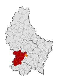
 Map of Luxembourg with Kopstal highlighted in orange, and the canton in dark red | |
| Coordinates: 49°39′51″N 6°04′19″E / 49.664167°N 6.071944°E | |
| Country | |
| Canton | Capellen |
| Government | |
| • Mayor | Thierry Schuman |
| Area | |
• Total | 7.9 km2 (3.1 sq mi) |
| • Rank | 97th of 100 |
| Highest elevation | 392 m (1,286 ft) |
| • Rank | 59th of 100 |
| Lowest elevation | 245 m (804 ft) |
| • Rank | 55th of 100 |
| Population (2023) | |
• Total | 4,286 |
| • Rank | 43rd of 100 |
| • Density | 540/km2 (1,400/sq mi) |
| • Rank | 17th of 100 |
| Time zone | UTC+1 (CET) |
| • Summer (DST) | UTC+2 (CEST) |
| LAU 2 | LU0000107 |
| Website | kopstal.lu |
Kopstal (Luxembourgish: Koplescht) is a commune and a small town in central Luxembourg. The towns of Kopstal and Bridel belong to this commune. Kopstal is a small town, with a population of 1,045 as of 2023,[1] located in a valley between forested hills situated beneath Bridel.
Kopstal was formed on 1 July 1853, when it was detached from the communes of Kehlen (in Capellen canton) and Steinsel (in Luxembourg canton). The law forming Kopstal was passed on the 22 February 1853.[2]
- ^ "Registre national des personnes physiques RNPP : Population par localité". data.public.lu. 2024-01-07.
- ^ (in French and German) "Mémorial A, 1853, No. 31" (PDF). Service central de législation. Retrieved 2006-08-15.[permanent dead link]
Previous Page Next Page


