Back لويس (المملكة المتحدة) Arabic لوئیس (شهرک) AZB Луис (град) Bulgarian Lewes Catalan Lewes (kapital sa kondado) CEB Lewes Czech Lewes CY Lewes Danish Lewes German Lewes EO
| Lewes | |
|---|---|
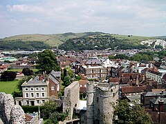
 Lewes viewed from Lewes Castle | |
 Coat of arms of Lewes | |
Location within East Sussex | |
| Area | 11.4 km2 (4.4 sq mi) [1] |
| Population | 17,297 (Parish-2011)[2] |
| • Density | 1,420/km2 (3,700/sq mi) |
| Demonym | Lewesian |
| OS grid reference | TQ420104 |
| • London | 71 km (44 mi) N |
| Civil parish |
|
| District | |
| Shire county | |
| Region | |
| Country | England |
| Sovereign state | United Kingdom |
| Post town | LEWES |
| Postcode district | BN7 |
| Dialling code | 01273 |
| Police | Sussex |
| Fire | East Sussex |
| Ambulance | South East Coast |
| UK Parliament | |
| Website | lewes-tc |
Lewes (/ˈluːɪs/ ⓘ) is the county town of East Sussex, England.[note 1] The town is the administrative centre of the wider district of the same name. It lies on the River Ouse at the point where the river cuts through the South Downs.
A traditional market town and centre of communications, in 1264 it was the site of the Battle of Lewes. The town's landmarks include Lewes Castle, Lewes Priory, Bull House (the former home of Thomas Paine), Southover Grange and public gardens, and a 16th-century timber-framed Wealden hall house known as Anne of Cleves House. Other notable features of the area include the Glyndebourne festival, the Lewes Bonfire celebrations and the Lewes Pound.
- ^ "East Sussex in Figures". East Sussex County Council. Archived from the original on 28 December 2012. Retrieved 26 April 2008.
- ^ "Town population 2011". Archived from the original on 16 October 2015. Retrieved 12 October 2015.
- ^ "About Sussex". Sussex County Flag. 11 March 2015. Archived from the original on 3 February 2019. Retrieved 2 February 2019.
- ^ "A List of Some Towns of Commercial, Antiquarian, Historical or Sanitary Interest". A Reference Book of Modern Geography. Longmans, Green and Co. 1870. Archived from the original on 23 January 2021. Retrieved 2 February 2019.
- ^ "Chichester, Lewes". Sussex; being an historical, topographical, and general description of every rape, hundred, river, town, borough, parish, village, hamlet, castle, monastery, and gentleman's seat in that county, etc. E. Taylor. 1834. Archived from the original on 23 January 2021. Retrieved 17 November 2019.
- ^ General history of Horsham – The town as county centre, Victoria County History of Sussex, Volume VI British History Online Archived 27 September 2007 at the Wayback Machine
Cite error: There are <ref group=note> tags on this page, but the references will not show without a {{reflist|group=note}} template (see the help page).
