Our website is made possible by displaying online advertisements to our visitors.
Please consider supporting us by disabling your ad blocker.
Maadi
Maadi
المعادى | |
|---|---|
District 12 | |
| Arabic transcription(s) | |
| • Common | Al-Ma‛adi |
 | |
 Map of Maadi (inset: map of Egypt) | |
| Coordinates: 29°58′3″N 31°15′0″E / 29.96750°N 31.25000°E | |
| Country | Egypt |
| Governorate | Cairo |
| Population (2023) | |
• Total | 95,190 |
| Time zone | UTC+2 (Egypt Standard Time) |
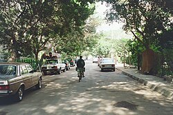
Maadi (Egyptian Arabic: المعادى el-Maʿādi [elmæˈʕæːdi]) is a leafy and once suburban district in the Southern Area of Cairo, Egypt,[1] on the east bank of the Nile about 12 kilometers (7.5 mi) upriver from downtown Cairo. The modern extensions north east and east of Maadi, New Maadi and Zahraa al-Maadi are administratively part of the Basatin district.[1]
The Nile at Maadi is paralleled by the Corniche, a waterfront promenade and the main road north into Cairo. There is no bridge across the Nile at Maadi; the nearest one is located at El Mounib along the Ring Road (Tarik El-Da'eri, English: The Round Road) on the way north to the downtown.
Maadi's population was estimated to be 85,000 according to the 2017 census.[2] The district is popular with international expatriates as well as Egyptians and is home to many embassies, as well as major international schools, sporting clubs, and cultural institutions such as the Supreme Constitutional Court of Egypt and the national Egyptian Geological Museum.
Previous Page Next Page


