Our website is made possible by displaying online advertisements to our visitors.
Please consider supporting us by disabling your ad blocker.
Mudgee
| Mudgee New South Wales | |||||||||
|---|---|---|---|---|---|---|---|---|---|
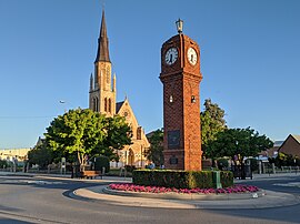
 View of the town centre, showing War Memorial Clock Tower | |||||||||
 | |||||||||
| Coordinates | 32°35′43″S 149°35′16″E / 32.595174°S 149.587805°E | ||||||||
| Population | 11,457 (2021)[1] | ||||||||
| Postcode(s) | 2850 | ||||||||
| Elevation | 454 m (1,490 ft) | ||||||||
| Location |
| ||||||||
| LGA(s) | Mid-Western Regional Council | ||||||||
| Region | Central West | ||||||||
| County | Wellington | ||||||||
| State electorate(s) | Dubbo | ||||||||
| Federal division(s) | Calare | ||||||||
| |||||||||
Mudgee (/mʌdʒi/) is a town in the Central West of New South Wales, Australia. It is in the broad fertile Cudgegong River valley 261 km (162 mi) north-west of Sydney and is the largest town in the Mid-Western Regional Council local government area as well as being the council seat. At the 2021 Census, its population was 11,457.[1] The district lies across the edge of the geological structure known as the Sydney Basin.[2]
- ^ a b Cite error: The named reference
Census21was invoked but never defined (see the help page). - ^ Sydney Basin (Map). New South Wales Department of Primary Industries.
Previous Page Next Page


