Back Nuth AF نوت (هولندا) Arabic نوت (تجمع سكان فى ليمبورج) ARZ Nuth Catalan Gemeente Nuth CEB Nuth Danish Nuth German Nuth EU نوت (هلند) FA Nuth French
Nuth
Nut (Limburgish) | |
|---|---|
Former Municipality | |
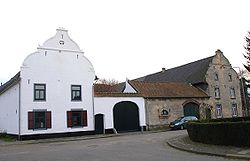
 Old farmhouse in Arensgenhout | |
| Coordinates: 50°55′N 5°53′E / 50.917°N 5.883°E | |
| Country | Netherlands |
| Province | Limburg |
| Municipality | Beekdaelen |
| Merged | 2019 |
| Area | |
• Total | 3.27 km2 (1.26 sq mi) |
| Elevation | 86 m (282 ft) |
| Population (2021)[1] | |
• Total | 4,595 |
| • Density | 1,400/km2 (3,600/sq mi) |
| Demonym | Nutter |
| Time zone | UTC+1 (CET) |
| • Summer (DST) | UTC+2 (CEST) |
| Postcode | 6361[1] |
| Area code | 045 |
| Website | www |
Nuth (Dutch: [nʏt] ⓘ; Limburgish: Nut [nʏt]) is a village and a former municipality in the province of Limburg, situated in the southern Netherlands. In January 2019, the municipality merged with Schinnen and Onderbanken to form Beekdaelen.[3]
The village of Nuth has 4,595 inhabitants (1 January 2021),[1] and is with that the largest village of the municipality. The town hall of the municipality Nuth was also situated in the village Nuth. The other villages in the municipality were Hulsberg with 3972 inhabitants, Schimmert with 3184, Wijnandsrade with 1623 and Vaesrade with 997 inhabitants (data: 1-1-2021). The other population centres belong to one of the following villages.
- ^ a b c d "Kerncijfers wijken en buurten 2021". Central Bureau of Statistics. Retrieved 23 April 2022.
two entries
- ^ "Postcodetool for 6361BZ". Actueel Hoogtebestand Nederland (in Dutch). Het Waterschapshuis. Retrieved 16 November 2013.
- ^ "Gemeenteraad Beekdaelen beëdigd in gemeentehuis Nuth" [Town council of Beekdaelen sworn in at Nuth municipality office] (in Dutch). 1Limburg. Retrieved 2 March 2019.


