Back Pangkal Pinang ACE بانغكال بينانغ Arabic Kota Pangkal Pinang BAN Пангкал–Пінанг BE Kota Pangkalpinang BEW Pangkalpinang BTM Pangkal Pinang Catalan Pangkalpinang CEB Pangkalpinang Czech Pangkal Pinang German
Pangkalpinang
Pin-kong | |
|---|---|
| City of Pangkalpinang Kota Pangkalpinang | |
| Other transcription(s) | |
| • Jawi | ڤڠكل ڤينڠ |
| • Mandarin | 邦加槟港 (Simplified) 邦加檳港 (Traditional) Bāng jiā bīn gǎng (Pinyin) |
| • Hakka | 槟港 (Simplified) 檳港 (Traditional) Pin-kóng (Pha̍k-fa-sṳ) |
Pangkalpinang city view Fuk Tet Che Temple Wilhelmina Park Emas Bridge Air Anyir Power Plant Batu Bolong Beach | |
| Motto(s): | |
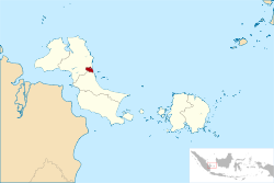
 Location within Bangka Belitung Islands | |
| Coordinates: 2°8′S 106°7′E / 2.133°S 106.117°E | |
| Country | |
| Region | Sumatra |
| Province | |
| Founded | 17 September 1757 |
| Government | |
| • Mayor | Maulan Aklil |
| • Vice Mayor | Muhammad Sopian |
| Area | |
• Total | 104.54 km2 (40.36 sq mi) |
| Elevation | 0−13 m (−43 ft) |
| Population (mid 2022 estimate)[1] | |
• Total | 226,297 |
| • Density | 2,200/km2 (5,600/sq mi) |
| Demographics | |
| • Ethnic groups | Malay Javanese Batak, Chinese Bugis[2] |
| • Religion | Islam 52.31% Buddhism 36.18% Confucianism 4.56% Christian 3.41% Catholic 3.21% Hinduism 0.04% Others 0.27%[3] |
| • Languages | Indonesian (official) Chinese Malay English (regional) |
| Time zone | UTC+7 (Indonesia Western Time) |
| Area code | (+62) 717 |
| Vehicle registration | BN |
| Website | pangkalpinangkota.go.id |
| Pangkalpinang | |||||||||||||||||||||
|---|---|---|---|---|---|---|---|---|---|---|---|---|---|---|---|---|---|---|---|---|---|
| Traditional Chinese | 邦加檳港 | ||||||||||||||||||||
| Simplified Chinese | 邦加槟港 | ||||||||||||||||||||
| |||||||||||||||||||||
| Pin-kong | |||||||||||||||||||||
| Traditional Chinese | 檳港 | ||||||||||||||||||||
| Simplified Chinese | 槟港 | ||||||||||||||||||||
| |||||||||||||||||||||
Pangkalpinang, colloquially written as Pangkal Pinang, also known as Pin-kong in Hakka, is the capital and largest city of the Bangka Belitung Islands Province in Indonesia. It is located on Bangka Island's east coast, the city is divided into seven districts (kecamatan) and has 42 wards (kelurahan).
It covers an area of 89.40 square kilometres (34.52 sq mi)[4] and it had a population of 174,838 at the 2010 Census[5] and 218,568 at the 2020 Census;[6] the official estimate as at mid 2022 was 226,297.[1] The city's average population density was about 2,165 per square kilometre in mid 2022. The Rangkui River divides the city into two parts, and Jalan Merdeka is its geographic center.
Pangkalpinang's population consists largely of ethnic Malays and Hakka Chinese people. There are also smaller immigrant communities of other ethnic groups, such as Batak and Minangkabau. Landmarks in the city include the Timah Museum, a Chinese temple, the Cathedral of St. Joseph, the Bangka Botanical Garden, and the Pasir Padi beach.
- ^ a b Badan Pusat Statistik, Jakarta, 2023, Kota Pangkalpinang Dalam Angka 2023 (Katalog-BPS 1102001.1971)
- ^ Aris Ananta; Evi Nurvidya Arifin; M. Sairi Hasbullah; Nur Budi Handayani; dan Agus Pramono (2015). Demography of Indonesia's Ethnicity. Institute of Southeast Asian Studies dan BPS – Statistics Indonesia.
- ^ Data Sensus Penduduk 2010 - Badan Pusat Statistik Republik Indonesia <http://sp2010.bps.go.id/index.php/site/tabel?tid=321&wid=8100000000>
- ^ There is a discrepancy with the figures reported by national office of BPS and that reported by the local BPS, which gives 104.54 km2 as shown in the table of districts.
- ^ Biro Pusat Statistik, Jakarta, 2011.
- ^ Badan Pusat Statistik, Jakarta, 2021.


