Back روسينها Arabic Rocinha Catalan Rocinha German Rocinha EO Rocinha Spanish Rocinha EU Rocinha Finnish Rocinha French Rocinha FRP רוסיניה HE
Rocinha | |
|---|---|
Neighborhood | |
 | |
| Coordinates: 22°59′19″S 43°14′54″W / 22.98861°S 43.24833°W | |
| Country | |
| State | Rio de Janeiro |
| Municipality/City | Rio de Janeiro |
| Zone | South Zone |
| Administrative Region | Rocinha |
| Area | |
• Total | 143.72 ha (355.14 acres) |
| Population (2017)[1] | |
• Total | 69,356 (2,010 census) |
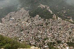
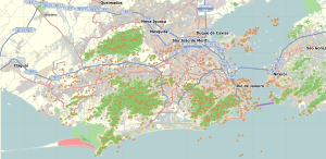
Rocinha (Portuguese pronunciation: [ʁɔˈsĩɲɐ], lit. 'little farm') is a favela in Brazil, located in Rio de Janeiro's South Zone between the districts of São Conrado and Gávea. Rocinha is built on a steep hillside overlooking Rio de Janeiro, and is located about one kilometre from a nearby beach. Most of the favela is on a very steep hill, with many trees surrounding it. Around 200,000 people live in Rocinha, making it the most populous in Rio de Janeiro.[2]
Although Rocinha is officially categorized as a neighbourhood, many still refer to it as a favela. It developed from a shanty town into an urbanized slum. Today, almost all the houses in Rocinha are made from concrete and brick. Some buildings are three and four storeys tall and almost all houses have basic plumbing and electricity. Compared to simple shanty towns or slums, Rocinha has a better developed infrastructure and hundreds of businesses such as banks, medicine stores, bus routes, cable television, including locally based channel TV ROC (TV Rocinha), and, at one time, a McDonald's franchise.[3] These factors help classify Rocinha as a favela bairro, or favela neighborhood.
- ^ "Bairro: Rocinha". Prefeitura do Rio de Janeiro. Archived from the original on 29 November 2014. Retrieved 25 November 2014.
- ^ Enfoco (2023-03-17). "Rocinha não é mais a maior favela do Brasil, diz IBGE | Enfoco". Enfoco - O seu site de notícias (in Brazilian Portuguese). Retrieved 2024-02-21.
- ^ Chetwynd, Gareth (2004-04-17). "Deadly setback for a model favela". The Guardian. London. Archived from the original on 2013-08-28. Retrieved 2010-05-22.

