Our website is made possible by displaying online advertisements to our visitors.
Please consider supporting us by disabling your ad blocker.

Strullendorf
Strullendorf | |
|---|---|
 Town hall | |
 Coat of arms | |
Location of Strullendorf within Bamberg district 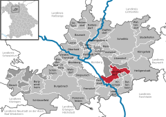 | |
 Strullendorf  Strullendorf | |
| Coordinates: 49°50′N 10°58′E / 49.833°N 10.967°E | |
| Country | Germany |
| State | Bavaria |
| Admin. region | Oberfranken |
| District | Bamberg |
| Subdivisions | 8 Gemeindeteile |
| Government | |
| • Mayor (2020–26) | Wolfgang Desel[1] (CSU) |
| Area | |
• Total | 31.69 km2 (12.24 sq mi) |
| Elevation | 251 m (823 ft) |
| Population (2023-12-31)[2] | |
• Total | 7,875 |
| • Density | 250/km2 (640/sq mi) |
| Time zone | UTC+01:00 (CET) |
| • Summer (DST) | UTC+02:00 (CEST) |
| Postal codes | 96129 |
| Dialling codes | 09543 |
| Vehicle registration | BA |
| Website | www.strullendorf.de |
Strullendorf is a community in the Upper Franconian district of Bamberg. It is an ideal place for hiking and cycling tours along with many breweries[3]
- ^ Liste der ersten Bürgermeister/Oberbürgermeister in kreisangehörigen Gemeinden, Bayerisches Landesamt für Statistik, 15 July 2021.
- ^ Genesis Online-Datenbank des Bayerischen Landesamtes für Statistik Tabelle 12411-003r Fortschreibung des Bevölkerungsstandes: Gemeinden, Stichtag (Einwohnerzahlen auf Grundlage des Zensus 2011).
- ^ "Strullendorf". www.bamberg.info (in German). Retrieved 2024-12-06.
Previous Page Next Page

