Back Propinsi Sulu ACE سولو (الفلبين) Arabic سولو (فیلیپین) AZB Sulu BCL Sulu CBK-ZAM Sulu CEB Provinz Sulu German Suluo EO Provincia de Joló Spanish سولو (فیلیپین) FA
This article needs additional citations for verification. (August 2014) |
Sulu
| |
|---|---|
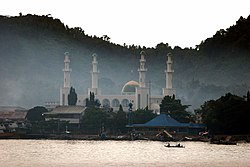
(from top: left to right) Sulu Provincial Capitol Building in Jolo, scenery in Hadji Panglima Tahil, sunrise in Lugus and Tulay Mosque in Jolo. | |
 Location in the Philippines | |
| Coordinates: 6°N 121°E / 6°N 121°E | |
| Country | |
| Region | Undetermined |
| Founded | September 1, 1914 |
| Capital | |
| Largest Municipality | Jolo |
| Government | |
| • Type | Sangguniang Panlalawigan |
| • Governor | Abdusakur M. Tan (Lakas) |
| • Vice Governor | Abdusakur A. Tan II (Lakas) |
| • Legislature | Sulu Provincial Board |
| Area | |
• Total | 1,600.40 km2 (617.92 sq mi) |
| • Rank | 66th out of 81 |
| Highest elevation | 811 m (2,661 ft) |
| Population (2020 census)[3] | |
• Total | 1,000,108 |
| • Rank | 28th out of 81 |
| • Density | 620/km2 (1,600/sq mi) |
| • Rank | 10th out of 81 |
| Demonyms | Suluan Tausug |
| Divisions | |
| • Independent cities | 0 |
| • Component cities | 0 |
| • Municipalities | |
| • Barangays | 410 |
| • Districts | Legislative districts of Sulu |
| Time zone | UTC+8 (PHT) |
| ZIP code | 7400–7416 |
| IDD : area code | +63 (0)68 |
| ISO 3166 code | PH-SLU |
| Spoken languages | |
| Income classification | 2nd class |
Sulu ([sʊˈlu]), officially the Province of Sulu (Tausūg: Wilāya sin Lupa' Sūg; Tagalog: Lalawigan ng Sulu), is a province of the Philippines in the Sulu Archipelago.
It was part of the Bangsamoro Autonomous Region in Muslim Mindanao (BARMM), until the Supreme Court of the Philippines on September 9, 2024 declared its inclusion to be unconstitutional because of the province's simple majority vote against it during the 2019 Bangsamoro autonomy plebiscite.[4]
Its capital is Jolo on the island of the same name.[5] Maimbung, the royal capital of the Sultanate of Sulu, is also located in the province. Sulu is along the southern border of the Sulu Sea and the northern boundary of the Celebes Sea.
Out of all 82 provinces in the Philippines, it is the poorest, as evidenced by it having the highest poverty rate.[citation needed] According to the Philippine Statistics Authority, poverty incidence in Sulu had reduced in 2021 with 51 percent compared to 75.3 percent in 2018. According to the PSA, this reduction in poverty incidence is an improvement for the province.[6]
- ^ "Brief Profile". Province of Sulu, Philippines. Archived from the original on February 26, 2011. Retrieved April 18, 2016.
Various government agencies report varying land areas for Sulu. According to the National Mapping and Resources Information Authority, Sulu has a total land area of 160,040 hectares. On the other hand, based on the Philippine Statistics Authority (NSO) 2000 Demographic and Socio-Economic profile, the province has a land area of 1,754.6.
- ^ Province of Sulu: Brief Profile Archived February 26, 2011, at the Wayback Machine (There seems to be major discrepancies among authoritative sources: 343,699 ha (NSCB 2007), 175,460 ha (NSCB 2000), 167,377 ha (NAMRIA))
- ^ Census of Population (2020). Table B - Population and Annual Growth Rates by Province, City, and Municipality - By Region. Philippine Statistics Authority. Retrieved July 8, 2021.
- ^ "SC Upholds Validity of Bangsamoro Organic Law; Declares Sulu not Part of Bangsamoro Region". Supreme Court of the Philippines. September 9, 2024. Retrieved September 9, 2024.
- ^ "Jolo Branch Museum". National Museum. Archived from the original on August 2, 2019. Retrieved February 22, 2020.
- ^ Manoguid, Bart (February 15, 2023). "SAAD Sulu creates significant progress in agri-development, pines for consistent social protection initiatives - Special Area for Agricultural Development". Retrieved October 13, 2024.


