Our website is made possible by displaying online advertisements to our visitors.
Please consider supporting us by disabling your ad blocker.
Tekokota
| Tekokota | ||
|---|---|---|
 | ||
| Gewässer | Pazifischer Ozean | |
| Archipel | Tuamotu-Archipel | |
| Geographische Lage | 17° 20′ S, 142° 37′ W | |
|
| ||
| Anzahl der Inseln | – | |
| Hauptinsel | – | |
| Landfläche | 1 km² | |
| Lagunenfläche | 5,1 km² | |
| Einwohner | unbewohnt | |
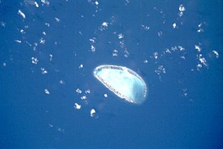
Tekokota ist ein unbewohntes Atoll des Tuamotu-Archipels in Französisch-Polynesien. Das Hikueru Atoll liegt Tekokota 22 km in südlicher Richtung entfernt am nächsten. Das Atoll hat eine ovale Form von etwa 5 km Länge und 3,5 km Breite. Der westliche Teil des Atolls liegt unter Wasser.
Tekokota gehört administrativ zur Gemeinde Hikueru.
Previous Page Next Page


