Back فآتيندورف Arabic Wattendorf BAR Ваттендорф CE Wattendorf (munisipyo) CEB Wattendorf German Wattendorf EO Wattendorf Spanish Wattendorf EU واتندورف FA Wattendorf French
This article needs additional citations for verification. (September 2024) |
Wattendorf | |
|---|---|
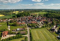
 Aerial view of Wattendorf | |
Location of Wattendorf within Bamberg district  | |
| Coordinates: 50°02′N 11°08′E / 50.033°N 11.133°E | |
| Country | Germany |
| State | Bavaria |
| Admin. region | Oberfranken |
| District | Bamberg |
| Municipal assoc. | Steinfeld |
| Subdivisions | 6 Ortsteile |
| Government | |
| • Mayor (2020–26) | Thomas Betz[1] (CSU) |
| Area | |
• Total | 22.23 km2 (8.58 sq mi) |
| Elevation | 530 m (1,740 ft) |
| Population (2023-12-31)[2] | |
• Total | 636 |
| • Density | 29/km2 (74/sq mi) |
| Time zone | UTC+01:00 (CET) |
| • Summer (DST) | UTC+02:00 (CEST) |
| Postal codes | 96196 |
| Dialling codes | 09504 |
| Vehicle registration | BA |
| Website | www.wattendorf-oberfranken.de |
Wattendorf isa municipality in the Upper Franconian district of Bamberg and a member of the administrative community (Verwaltungsgemeinschaft) of Steinfeld.
- ^ Liste der ersten Bürgermeister/Oberbürgermeister in kreisangehörigen Gemeinden, Bayerisches Landesamt für Statistik, 15 July 2021.
- ^ Genesis Online-Datenbank des Bayerischen Landesamtes für Statistik Tabelle 12411-003r Fortschreibung des Bevölkerungsstandes: Gemeinden, Stichtag (Einwohnerzahlen auf Grundlage des Zensus 2011).


