Our website is made possible by displaying online advertisements to our visitors.
Please consider supporting us by disabling your ad blocker.
Longreach, Queensland
| Longreach Queensland | |||||||||||||||
|---|---|---|---|---|---|---|---|---|---|---|---|---|---|---|---|
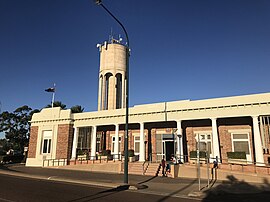
 Longreach Shire Hall and Water Tower | |||||||||||||||
| Coordinates | 23°26′32″S 144°14′57″E / 23.4422°S 144.2491°E | ||||||||||||||
| Population | 3,124 (2021 census)[1] | ||||||||||||||
| • Density | 0.132980/km2 (0.34442/sq mi) | ||||||||||||||
| Established | 1888 | ||||||||||||||
| Postcode(s) | 4730 | ||||||||||||||
| Elevation | 191.0 m (627 ft) | ||||||||||||||
| Area | 23,492.3 km2 (9,070.4 sq mi) | ||||||||||||||
| Time zone | AEST (UTC+10:00) | ||||||||||||||
| Location |
| ||||||||||||||
| LGA(s) | Longreach Region | ||||||||||||||
| County | Portland County | ||||||||||||||
| State electorate(s) | Gregory | ||||||||||||||
| Federal division(s) | Maranoa | ||||||||||||||
| |||||||||||||||
| |||||||||||||||
Longreach is a rural town and locality in the Longreach Region, Queensland, Australia.[2][3] It is the administrative centre of the Longreach Regional Council, which was established in 2008 as a merger of the former Longreach, Ilfracombe, and Isisford shires. Longreach is a well known tourist destination due to its aviation history and importance. In the 2021 census, the locality of Longreach had a population of 3,124.[1]
- ^ a b Cite error: The named reference
Census2021was invoked but never defined (see the help page). - ^ "Longreach – town in Longreach Region (entry 20044)". Queensland Place Names. Queensland Government. Retrieved 11 June 2019.
- ^ "Longreach – locality in Longreach Region (entry 49510)". Queensland Place Names. Queensland Government. Retrieved 11 June 2019.
Previous Page Next Page


