Our website is made possible by displaying online advertisements to our visitors.
Please consider supporting us by disabling your ad blocker.
Chichester, Quebec
Chichester | |
|---|---|
 | |
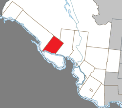
 Location within Pontiac RCM | |
| Coordinates: 45°55′N 77°07′W / 45.917°N 77.117°W[1] | |
| Country | Canada |
| Province | Quebec |
| Region | Outaouais |
| RCM | Pontiac |
| Constituted | January 1, 1857 |
| Named for | Chichester[1] |
| Government | |
| • Mayor | Donald Gagnon |
| • Federal riding | Pontiac |
| • Prov. riding | Pontiac |
| Area | |
• Total | 230.63 km2 (89.05 sq mi) |
| • Land | 218.74 km2 (84.46 sq mi) |
| Population (2021)[3] | |
• Total | 350 |
| • Density | 1.6/km2 (4/sq mi) |
| • Pop (2016-21) | |
| • Dwellings | 247 |
| Time zone | UTC−5 (EST) |
| • Summer (DST) | UTC−4 (EDT) |
| Postal code(s) | |
| Area code | 819 |
| Highways | No major routes |
Chichester is a township municipality and village in the Canadian province of Quebec, located within the Pontiac Regional County Municipality.
Chichester is located along the north shores of the Ottawa River across from Chapeau on Allumette Island.
Its settlements include Chichester and Nichabau. Nichabau, also known as Nicabeau or Nichabong, is a scenic hamlet located northwest of Chichester in what used to be referred to as Poupore's Limits. It is noted for its great number of square log homes. [4]
- ^ a b Cite error: The named reference
toponymiewas invoked but never defined (see the help page). - ^ a b "Répertoire des municipalités: Geographic code 84090". www.mamh.gouv.qc.ca (in French). Ministère des Affaires municipales et de l'Habitation.
- ^ a b "Chichester, Canton (municipalité de) (CT) Census Profile, 2021 Census of Population". www12.statcan.gc.ca. Government of Canada - Statistics Canada. Retrieved 10 November 2022.
- ^ "Pontiac MRC Gateway: Chichester". Pontiac MRC Gateway. Archived from the original on October 7, 2006. Retrieved 2008-06-27.
Previous Page Next Page


