Our website is made possible by displaying online advertisements to our visitors.
Please consider supporting us by disabling your ad blocker.
Doncaster, Victoria
| Doncaster Melbourne, Victoria | |||||||||||||||
|---|---|---|---|---|---|---|---|---|---|---|---|---|---|---|---|
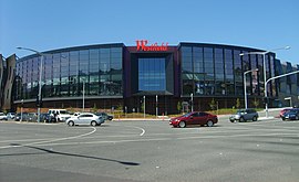
 The front of Westfield Doncaster | |||||||||||||||
 | |||||||||||||||
| Coordinates | 37°46′48″S 145°07′26″E / 37.78°S 145.124°E | ||||||||||||||
| Population | 25,020 (2021 census)[1] | ||||||||||||||
| • Density | 2,811/km2 (7,280/sq mi) | ||||||||||||||
| Established | 1860s | ||||||||||||||
| Postcode(s) | 3108 | ||||||||||||||
| Elevation | 108 m (354 ft) | ||||||||||||||
| Area | 8.9 km2 (3.4 sq mi) | ||||||||||||||
| Location | 18 km (11 mi) from Melbourne | ||||||||||||||
| LGA(s) | City of Manningham | ||||||||||||||
| State electorate(s) | Bulleen | ||||||||||||||
| Federal division(s) | Menzies | ||||||||||||||
| |||||||||||||||
Doncaster (/ˈdɒŋkɑːstər/ DONK-ah-stər)[2] is a suburb of Melbourne, Victoria, Australia, 15 km east of Melbourne's Central Business District, located within the City of Manningham local government area. Doncaster recorded a population of 25,020 at the 2021 census.[1]
The suburb, which is situated on 8.9 km2 of land, around the top of the 120 m high Doncaster Hill. The suburb consists of a central area along the top of Doncaster Hill, which includes several historical buildings along Doncaster Road, the Westfield Doncaster Shopping Centre and surrounding high-rise apartments, while the rest of the suburb is typical of many of Melbourne's eastern suburbs, with extensive low-density housing.
- ^ a b "2021 Census QuickStats Doncaster". Australian Bureau of Statistics. Retrieved 3 July 2022.
- ^ "A definitive guide on how to pronounce Melbourne suburb names". Domain. 6 June 2018. Retrieved 7 June 2018.
Previous Page Next Page


