Our website is made possible by displaying online advertisements to our visitors.
Please consider supporting us by disabling your ad blocker.
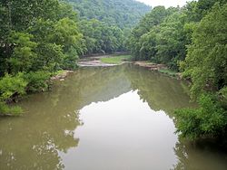
Guyandotte River
| Guyandotte River | |
|---|---|
 The Guyandotte River in West Logan in 2007 | |
 | |
| Location | |
| Country | United States of America |
| State | West Virginia |
| Physical characteristics | |
| Mouth | Huntington, West Virginia |
| Discharge | |
| • location | mouth |
| • average | 2,304.35 cu ft/s (65.252 m3/s) (estimate)[1] |
| Basin features | |
| River system | Ohio River |
The Guyandotte River is a tributary of the Ohio River, approximately 166 mi (267 km) long, in southwestern West Virginia in the United States. It was named after the French term for the Wendat Native Americans. It drains an area of the unglaciated Allegheny Plateau south of the Ohio between the watersheds of the Kanawha River to the northeast and Twelvepole Creek and the Big Sandy River to the southwest. Via the Ohio River, it is part of the Mississippi River watershed.
- ^ United States Environmental Protection Agency. "Watershed Report: Guyandotte River". watersgeo.epa.gov. Archived from the original on 2021-07-03. Retrieved 2021-07-03.
Previous Page Next Page


