Our website is made possible by displaying online advertisements to our visitors.
Please consider supporting us by disabling your ad blocker.
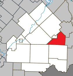
Hampden, Quebec
Hampden | |
|---|---|
 Pain de Sucre | |
 Location within Le Haut-Saint-François RCM | |
| Coordinates: 45°30′N 71°15′W / 45.5°N 71.25°W[1] | |
| Country | |
| Province | |
| Region | Estrie |
| RCM | Le Haut-Saint-François |
| Constituted | January 1, 1874 |
| Government | |
| • Mayor | Bertrand Prévost |
| • Federal riding | Compton—Stanstead |
| • Prov. riding | Mégantic |
| Area | |
• Total | 111.80 km2 (43.17 sq mi) |
| • Land | 111.68 km2 (43.12 sq mi) |
| Population | |
• Total | 193 |
| • Density | 1.7/km2 (4/sq mi) |
| • Pop 2016-2021 | |
| • Dwellings | 114 |
| Time zone | UTC−5 (EST) |
| • Summer (DST) | UTC−4 (EDT) |
| Postal code(s) | |
| Area code | 819 |
| Highways | |
| Website | www |
Hampden is a township municipality of about 200 people in Le Haut-Saint-François Regional County Municipality, in the Estrie region of Quebec, Canada.
Previous Page Next Page


