Our website is made possible by displaying online advertisements to our visitors.
Please consider supporting us by disabling your ad blocker.
Portal:New England
The New England Portal New England is a region consisting of six states in the Northeastern United States: Connecticut, Maine, Massachusetts, New Hampshire, Rhode Island, and Vermont. It is bordered by the state of New York to the west and by the Canadian provinces of New Brunswick to the northeast and Quebec to the north. The Gulf of Maine and Atlantic Ocean are to the east and southeast, and Long Island Sound is to the southwest. Boston is New England's largest city and the capital of Massachusetts. Greater Boston is the largest metropolitan area, with nearly a third of New England's population; this area includes Worcester, Massachusetts, the second-largest city in New England; Manchester, New Hampshire, the largest city in New Hampshire; and Providence, Rhode Island, the capital of and largest city in Rhode Island. In 1620, the Pilgrims established Plymouth Colony, the second successful settlement in British America after the Jamestown Settlement in Virginia, founded in 1607. Ten years later, Puritans established Massachusetts Bay Colony north of Plymouth Colony. Over the next 126 years, people in the region fought in four French and Indian Wars until the English colonists and their Iroquois allies defeated the French and their Algonquian allies. (Full article...) Selected article
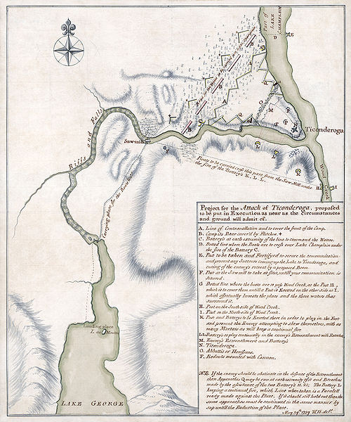
The Capture of Fort Ticonderoga occurred during the American Revolutionary War on May 10, 1775, when a small force of Green Mountain Boys led by Ethan Allen and Colonel Benedict Arnold overcame and looted a small British garrison. Cannons and other armaments from the fort were transported to Boston and used to fortify Dorchester Heights and break the stalemate at the Siege of Boston. After seizing Ticonderoga, a small detachment captured the nearby Fort Crown Point on May 11. On May 18, Arnold and 50 men boldly raided Fort Saint-Jean on the Richelieu River in southern Quebec, seizing military supplies, cannons, and the largest military vessel on Lake Champlain. Although the scope of this military action was relatively minor, it had significant strategic importance. It impeded communication between northern and southern units of the British Army, and gave the nascent Continental Army a staging ground for the invasion of Quebec later in 1775. It also involved two larger-than-life personalities in Allen and Arnold, each of whom sought to gain as much credit and honor as possible for these events. (Full article...)
Selected biography
Nathaniel Parker Willis was an American author, poet and editor who worked with several notable American writers including Edgar Allan Poe and Henry Wadsworth Longfellow. He became the highest-paid magazine writer of his day.
Born in Portland, Maine, Willis came from a family of publishers. Willis developed an interest in literature while attending Yale College and began publishing poetry. After graduation, he worked as an overseas correspondent for the New York Mirror. He eventually moved to New York and began to build his literary reputation. In 1846, he started his own publication, the Home Journal, which was eventually renamed Town & Country. Shortly after, Willis moved to a home on the Hudson River where he lived a semi-retired life until his death in 1867. (Full article...) Selected pictureGeneral images -The following are images from various New England-related articles on Wikipedia.
Did you know (auto-generated)
Related portalsMore did you know...
Selected State
Rhode Island
Incorporated 1776 Co-ordinates 41.7°N 71.5°W Rhode Island, officially the State of Rhode Island and Providence Plantations, is the smallest in area, the 8th least populous, but the 2nd most densely populated of the 50 U.S. states. Rhode Island was the first of the original Thirteen Colonies to declare independence from British rule, declaring itself independent on May 4, 1776, two months before any other colony. The State was also the last of the thirteen original colonies to ratify the United States Constitution. Rhode Island's official nickname is "The Ocean State," a reference to the State's geography, since Rhode Island has several large bays and inlets that amount to about fourteen (14) percent of its total area. Its land area is 1,045 square miles (2706 km2), but its total area is significantly larger. (Full article...) WikiProjectsAssociated WikimediaThe following Wikimedia Foundation sister projects provide more on this subject:
Discover Wikipedia using portals
|
Previous Page Next Page


