Our website is made possible by displaying online advertisements to our visitors.
Please consider supporting us by disabling your ad blocker.
Portal:New England
The New England Portal New England is a region consisting of six states in the Northeastern United States: Connecticut, Maine, Massachusetts, New Hampshire, Rhode Island, and Vermont. It is bordered by the state of New York to the west and by the Canadian provinces of New Brunswick to the northeast and Quebec to the north. The Gulf of Maine and Atlantic Ocean are to the east and southeast, and Long Island Sound is to the southwest. Boston is New England's largest city and the capital of Massachusetts. Greater Boston is the largest metropolitan area, with nearly a third of New England's population; this area includes Worcester, Massachusetts, the second-largest city in New England; Manchester, New Hampshire, the largest city in New Hampshire; and Providence, Rhode Island, the capital of and largest city in Rhode Island. In 1620, the Pilgrims established Plymouth Colony, the second successful settlement in British America after the Jamestown Settlement in Virginia, founded in 1607. Ten years later, Puritans established Massachusetts Bay Colony north of Plymouth Colony. Over the next 126 years, people in the region fought in four French and Indian Wars until the English colonists and their Iroquois allies defeated the French and their Algonquian allies. (Full article...) Selected article
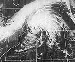
Tropical Storm Carrie was a strong tropical storm that affected the East Coast of the United States in early September 1972. The third tropical cyclone of the 1972 Atlantic hurricane season, Carrie formed on August 29 from a complex sequence of meteorological events starting with the emergence of a tropical wave into the Atlantic in the middle of August. Tracking nominally northward throughout its life, Carrie reached an initial peak intensity as a moderate tropical storm before nearly weakening back into tropical depression status. The storm began to reintensify owing to baroclinic processes after turning toward the northwest; its winds of 70 miles per hour (110 km/h) eclipsed the cyclone's previous maximum strength as it was transitioning into an extratropical system. The extratropical remnants of Carrie skirted eastern New England before making landfall in Maine on September 4 and dissipating over the Gulf of Saint Lawrence over the next two days. (Full article...)
Selected biography
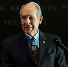
Thomas Jerome Hudner, Jr. is a retired officer of the United States Navy and a former naval aviator. He rose to the rank of captain, and received the Medal of Honor for his actions in trying to save the life of his wingman, Ensign Jesse L. Brown, during the Battle of Chosin Reservoir in the Korean War.
Born in Fall River, Massachusetts, Hudner attended Phillips Academy and the United States Naval Academy. Initially uninterested in aviation, he eventually took up flying and joined Fighter Squadron 32, flying the F4U Corsair at the outbreak of the Korean War. Arriving near Korea in October 1950, he flew support missions from the USS Leyte. On 4 December 1950, Hudner and Brown were among a group of pilots on patrol near the Chosin Reservoir when Brown's Corsair was struck by ground fire from Chinese troops and crashed. In an attempt to save Brown from his burning aircraft, Hudner intentionally crash-landed his own aircraft on a snowy mountain in freezing temperatures to help Brown. In spite of these efforts, Brown died of his injuries and Hudner was forced to evacuate, having also been injured in the landing. (Full article...) Selected picture Credit: Fcb981 (2007) John F. Kennedy Presidential Library, on the campus of the University of Massachusetts Boston
General images -The following are images from various New England-related articles on Wikipedia.
Did you know (auto-generated)
Related portalsMore did you know...
Selected State
Massachusetts
Incorporated 1775 Co-ordinates 42.3°N 71.8°W Massachusetts is the 7th least extensive, but the 14th most populous and the 3rd most densely populated of the 50 United States. The state features three separate metropolitan areas: Greater Boston in the east - which also includes all of Rhode Island - and the Springfield and Pittsfield metropolitan areas in the west. Massachusetts has played a significant historical, cultural, and commercial role in American history. Plymouth was the site of the colony founded in 1620 by the Pilgrims, passengers of the Mayflower. Harvard University, founded in 1636, is the oldest institution of higher learning in the United States. In 1692, the towns surrounding Salem experienced one of America's most infamous cases of mass hysteria, the Salem Witch Trials. Originally dependent on fishing, agriculture, and trade, Massachusetts was transformed into a manufacturing center during the Industrial Revolution. In the 21st century, Massachusetts is a leader in higher education, health care technology, high technology, and financial services (Full article...) WikiProjectsAssociated WikimediaThe following Wikimedia Foundation sister projects provide more on this subject:
Discover Wikipedia using portals
|
Previous Page Next Page


