Our website is made possible by displaying online advertisements to our visitors.
Please consider supporting us by disabling your ad blocker.
Tchefuncte River
| Tchefuncte River | |
|---|---|
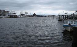
 Tchefuncte River as seen at Madisonville | |
 Tchefuncte River | |
| Location | |
| Country | United States |
| State | Louisiana |
| Parishes | |
| Physical characteristics | |
| Source | |
| • location | Tangipahoa Parish, Louisiana |
| • coordinates | 30°54′22″N 90°20′59″W / 30.90611°N 90.34972°W |
| Mouth | Lake Pontchartrain |
• location | Madisonville, St. Tammany Parish, Louisiana |
• coordinates | 30°22′36″N 90°09′38″W / 30.37667°N 90.16056°W |
| Length | 70 mi (110 km)[1] |
| Basin features | |
| Cities | |
| Tributaries | |
| • left | Bogue Falaya |
| GNIS number | 1628339[2] |
The Tchefuncte River (/tʃəˈfʌŋktə/ chə-FUNK-tə) drains into Lake Pontchartrain in Louisiana in the United States. It is about 70.0 miles (112.7 km) long.[1]
- ^ a b U.S. Geological Survey. National Hydrography Dataset high-resolution flowline data. The National Map, accessed June 20, 2011
- ^ "US Board on Geographic Names". United States Geological Survey. 2007-10-25. Retrieved 2019-08-17.
Previous Page Next Page


