Our website is made possible by displaying online advertisements to our visitors.
Please consider supporting us by disabling your ad blocker.
Marapoathutlwa
| Marapoathutlwa | |
| Suba | |
| Nasod | |
|---|---|
| Distrito | South East District |
| Gitas-on | 968 m (3,176 ft) |
| Tiganos | 24°35′34″S 25°58′51″E / 24.59278°S 25.98083°E |
| Timezone | CAT (UTC+2) |
| GeoNames | 1106218 |
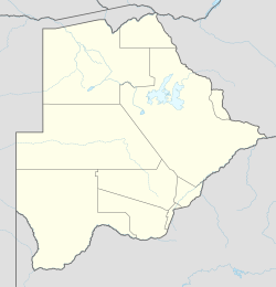
Suba ang Marapoathutlwa sa Botswana.[1] Nahimutang ni sa distrito sa South East District, sa habagatan-sidlakang bahin sa nasod, 10 km sa amihanan-sidlakan sa Gaborone ang ulohan sa nasod. Ang Marapoathutlwa mao ang bahin sa tubig-saluran sa Limpopo River.
- ↑ Cite error: Invalid
<ref>tag; no text was provided for refs namedgn1106218
Previous Page Next Page


