Our website is made possible by displaying online advertisements to our visitors.
Please consider supporting us by disabling your ad blocker.
Bwrdeistref Spelthorne
| Arwyddair | Ad Solem Prospicimus |
|---|---|
| Math | ardal an-fetropolitan, bwrdeisdref, ardal ddi-blwyf |
| Ardal weinyddol | Surrey |
| Prifddinas | Staines-upon-Thames |
| Poblogaeth | 103,551 |
| Gefeilldref/i | Melun |
| Daearyddiaeth | |
| Sir | Surrey (Sir seremonïol) |
| Gwlad | |
| Arwynebedd | 44.888 km² |
| Cyfesurynnau | 51.4333°N 0.5°W |
| Cod SYG | E07000213, E43000142 |
| Gwleidyddiaeth | |
| Corff deddfwriaethol | council of Spelthorne Borough Council |
 | |
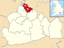
Ardal an-fetropolitan yn Surrey, De-ddwyrain Lloegr, yw Bwrdeistref Spelthorne (Saesneg: Borough of Spelthorne).
Mae gan yr ardal arwynebedd o 44.9 km², gyda 99,334 o boblogaeth yn ôl amcangyfrif cyfrifiad 2018.[1] Mae'n ffinio ar Fwrdeistref Elmbridge i'r de-ddwyrain, Bwrdeistref Runnymede i'r de-orllewin, Berkshire i'r gogledd-orllewin, a Llundain Fwyaf i'r gogledd-ddwyrain.

Ffurfiwyd yr ardal dan Ddeddf Llywodraeth Leol 1972, ar 1 Ebrill 1974.
Mae'r fwrdeistref yn hollol ddi-blwyf. Lleolir ei phencadlys yn nhref Staines-upon-Thames. Mae aneddiadau eraill yn yr ardal yn cynnwys trefi Ashford a Sunbury-on-Thames.
- ↑ City Population; adalwyd 26 Mai 2020
Previous Page Next Page


