Our website is made possible by displaying online advertisements to our visitors.
Please consider supporting us by disabling your ad blocker.
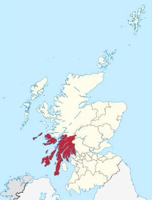
Argyll and Bute
| Argyll and Bute Earra-Ghàidheal agus Bòd | |
|---|---|
 | |
| Verwaltungssitz | Lochgilphead |
| Fläche | 6.909 km² (2.) |
| Einwohner | 88.166[1] (26.) |
| ISO 3166-2 | GB-AGB |
| ONS-Code | 00QD |
| Website | www.argyll-bute.gov.uk |
Argyll and Bute (gälisch: Earra-Ghàidheal agus Bòd) ist eine von 32 Council Areas in Schottland. Sie grenzt an Highland, Perth and Kinross, Stirling und West Dunbartonshire. Die östliche Grenze verläuft durch den Loch Lomond. Der Verwaltungssitz ist in Lochgilphead.
Der größte Teil des Verwaltungsbezirks gehörte einst zur traditionellen Grafschaft Argyll, mit Ausnahme der Region Morvern nördlich von Mull, das heute zu Highland gehört. Der Bezirk umfasst auch die im Firth of Clyde liegende Isle of Bute, die zur traditionellen Grafschaft Bute gehörte sowie den westlichen Teil der traditionellen Grafschaft Dunbartonshire.
Previous Page Next Page


