Our website is made possible by displaying online advertisements to our visitors.
Please consider supporting us by disabling your ad blocker.
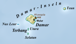
Damarinseln
| Damarinseln | ||
|---|---|---|
 | ||
| Gewässer | Bandasee | |
| Archipel | Barat-Daya-Inseln | |
| Geographische Lage | 7° 9′ S, 128° 39′ O | |
|
| ||
| Anzahl der Inseln | 5 | |
| Hauptinsel | Damar | |
| Gesamte Landfläche | 219 km² | |
| Einwohner | 7112 (2010) | |
 | ||
Die indonesischen Damarinseln gehören zu den Barat-Daya-Inseln.
Previous Page Next Page


