Our website is made possible by displaying online advertisements to our visitors.
Please consider supporting us by disabling your ad blocker.
Distrikt Bududa
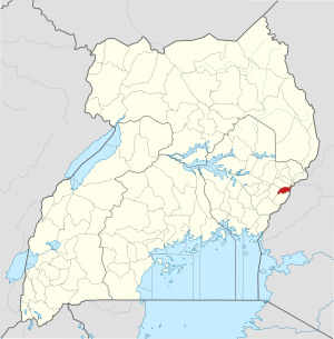
| Karte | |
|---|---|
 Lage von Bududa | |
| Basisdaten | |
| Hauptstadt | Bududa |
| Geographisches Zentrum | 1° 1′ N, 34° 20′ O |
| Fläche | 317,4 km² |
| Einwohnerzahl | 210.173 (Stand 2014) |
| Bevölkerungsdichte | 662,2 Einwohner/km² |
| Zeitzone | UTC +3 |
Bududa ist ein Distrikt (district) in Ost-Uganda. Bududa grenzt im Norden an den Distrikt Sironko, im Osten an Kenia, im Süden an den Distrikt Manafwa und im Westen an den Distrikt Mbale. Die Hauptstadt des Distrikts ist Bududa.[1] Der Distrikt Bududa hat 210.173 Einwohner und eine Fläche von 314,4 Quadratkilometern.[2]
Previous Page Next Page


