Our website is made possible by displaying online advertisements to our visitors.
Please consider supporting us by disabling your ad blocker.
Mota (Vanuatu)
| Mota
| ||
|---|---|---|
 | ||
| Gewässer | Korallenmeer | |
| Inselgruppe | Banks-Inseln | |
| Geographische Lage | 13° 50′ 40″ S, 167° 41′ 25″ O | |
|
| ||
| Länge | 5 km | |
| Breite | 4,5 km | |
| Fläche | 9,5 km² | |
| Höchste Erhebung | Mount Tawe 411 m | |
| Einwohner | 683 (2009) 72 Einw./km² | |
| Hauptort | Veverao | |
 | ||
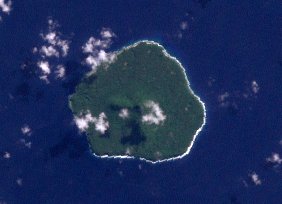
Mota, früher auch Sugarloaf Island, ist eine Vulkaninsel im Zentrum der Banks-Inseln im Norden des pazifischen Inselstaates Vanuatu. Administrativ gehört die Insel, wie alle Banks-Inseln, zur Provinz Torba.
Previous Page Next Page


