Our website is made possible by displaying online advertisements to our visitors.
Please consider supporting us by disabling your ad blocker.
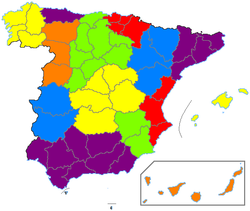
1822 territorial division of Spain


The 1822 territorial division of Spain was a rearrangement of the territory of Spain into various provinces, enacted briefly during the Trienio Liberal of 1820–1823. It is remembered today largely as a precursor to the similar 1833 territorial division of Spain; the provinces established in the latter remain, by and large, the basis for the present-day division of Spain into provinces.[1][2]
- ^ (in Spanish) Eduardo Barrenechea, Los 'gibraltares' de unas regiones en otras: Treviño, Llivia, Rincón de Ademuz..., El País, 1983-02-08. Accessed online 2000-12-30. This article comments on the persistence of the 1833 territorial division, in the context of a discussion of the remaining exclaves of various provinces.
- ^ Daniele Conversi, The Spanish Federalist Tradition and the 1978 Constitution Archived 2008-12-07 at the Wayback Machine, p. 12, footnote 63. Accessed online 2000-12-31.
Previous Page Next Page


