Our website is made possible by displaying online advertisements to our visitors.
Please consider supporting us by disabling your ad blocker.
Aabenraa Municipality
Aabenraa Municipality
| |
|---|---|
 | |
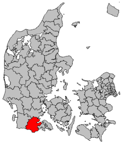
 Location in Denmark | |
| Coordinates: 55°01′59″N 9°25′01″E / 55.033°N 9.417°E | |
| Country | Denmark |
| Region | Southern Denmark |
| Established | 1 January 2007 |
| Government | |
| • Mayor | Jan Riber Jakobsen |
| Area | |
• Total | 941 km2 (363 sq mi) |
| Population (1. January 2024)[1] | |
• Total | 58,657 |
| • Density | 62/km2 (160/sq mi) |
| Time zone | UTC+1 (CET) |
| • Summer (DST) | UTC+2 (CEST) |
| Website | www |
Aabenraa Municipality (Danish: Aabenraa Kommune, German: Kommune Apenrade) is a kommune in the Region of Southern Denmark in southwestern Denmark.[2] The municipality has an area of 940.7 km2 and a total population of 58,657 (2024).[1] Its largest town and the site of its municipal council is the city of Aabenraa. The mayor of the municipality is Jan Riber Jakobsen, representing the Conservative People's Party.[3]
The island of Barsø is located in the northeast corner of the municipality in the Little Belt. Major communities include Lundsbjerg near the capital, Aabenraa; Sogard to the south, Felsted to the east, and Løjt Kirkeby to the north.[4] Løjt Kirkeby is connected by ferry service from the island of Barsø.[5][6]
- ^ a b BY2: Population 1. January by municipalities The Mobile Statbank from Statistics Denmark
- ^ "Statistikbanken". www.statistikbanken.dk. Retrieved 2016-09-08.
- ^ "Kommunal- og regionrådsvalg 2013". www.kmdvalg.dk. Retrieved 2016-09-08.
- ^ "Google Maps". Google Maps. Retrieved 2016-09-23.
- ^ Chisholm, Hugh, ed. (1911). . Encyclopædia Britannica. Vol. 2 (11th ed.). Cambridge University Press. p. 163.
- ^ "Google Maps". Google Maps. Retrieved 2016-09-23.
Previous Page Next Page


