Our website is made possible by displaying online advertisements to our visitors.
Please consider supporting us by disabling your ad blocker.
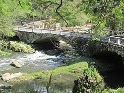
Almendares River
| Almendares River | |
|---|---|
 | |
 | |
| Location | |
| Country | Cuba |
| Physical characteristics | |
| Length | 47 km (29 mi) |
The Almendares River is a river that runs for 47 km in the western part of Cuba. It originates from the east of Tapaste and flows north-west into the Straits of Florida. The river acts as a water supply for Havana.[1]
The final stretch divides the municipalities of Plaza de la Revolución (Vedado district) and Playa (Miramar district). Part of the river valley forms the Almendares Park or Metropolitan Park of Havana (PMH), a few kilometers upstream from the ocean.[citation needed]
- ^ "Almendares River - river, Cuba". Encyclopedia Britannica. September 6, 2007. Retrieved January 20, 2022.
Previous Page Next Page


