Our website is made possible by displaying online advertisements to our visitors.
Please consider supporting us by disabling your ad blocker.
Amper
This article needs additional citations for verification. (October 2021) |
| Amper | |
|---|---|
 The Amper south of Fürstenfeldbruck | |
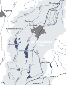
 The Ammer/Amper system within the Isar basin | |
| Location | |
| Country | Germany |
| State | Bavaria |
| Physical characteristics | |
| Source | |
| • location | Northern Limestone Alps |
| Mouth | |
• location | Isar |
• coordinates | 48°30′1″N 11°57′24″E / 48.50028°N 11.95667°E |
| Length | 190 km (120 mi) |
| Basin size | 3,248 km2 (1,254 sq mi) [1] |
| Discharge | |
| • average | ±45 m3/s (1,600 cu ft/s) |
| Basin features | |
| Progression | Isar→ Danube→ Black Sea |
The Amper, called the Ammer upstream of the Ammersee, through which it runs, is the largest tributary of the Isar in southern Bavaria, Germany. It flows generally north-eastward, reaching the Isar in Moosburg, about 185 kilometres (115 mi) from its source in the Ammergau Alps, with a flow of 45 m³/s. Including its tributary, Linder, it is 209.5 km (130.2 mi) long.[1] Major tributaries are the Glonn, which rises near Augsburg; the Würm, which is the outflow of Lake Starnberg; and the Maisach.
- ^ a b Complete table of the Bavarian Waterbody Register by the Bavarian State Office for the Environment (xls, 10.3 MB)
Previous Page Next Page


