Our website is made possible by displaying online advertisements to our visitors.
Please consider supporting us by disabling your ad blocker.
Andelle
| Andelle | |
|---|---|
 The Andelle at Radepont | |
 | |
| Location | |
| Country | France |
| Physical characteristics | |
| Source | |
| • location | Serqueux |
| • elevation | 201 m (659 ft) |
| Mouth | |
• location | The Seine at Pîtres |
• coordinates | 49°18′40″N 1°13′28″E / 49.31111°N 1.22444°E |
| Length | 56.9 km (35.4 mi) |
| Basin size | 740 km2 (290 sq mi) |
| Discharge | |
| • average | 7.2 m3/s (250 cu ft/s) |
| Basin features | |
| Progression | Seine→ English Channel |
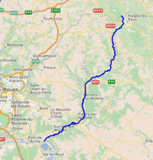
The Andelle (French pronunciation: [ɑ̃dɛl]) is a river of Normandy, France, 56.9 kilometres (35.4 mi) in length, flowing through the departments of Seine-Maritime and Eure. It is a right tributary of the Seine.[1]
Previous Page Next Page


