Our website is made possible by displaying online advertisements to our visitors.
Please consider supporting us by disabling your ad blocker.
Anglesey Airport
Anglesey Airport Maes Awyr Môn RAF Valley | |||||||||||||||
|---|---|---|---|---|---|---|---|---|---|---|---|---|---|---|---|
 | |||||||||||||||
 | |||||||||||||||
| Summary | |||||||||||||||
| Airport type | Military/Public | ||||||||||||||
| Operator | Bilfinger Europa Facility Management Limited | ||||||||||||||
| Serves | Anglesey Gwynedd | ||||||||||||||
| Location | Llanfair yn Neubwll, Isle of Anglesey | ||||||||||||||
| Elevation AMSL | 37 ft / 11 m | ||||||||||||||
| Coordinates | 53°14′53″N 004°32′07″W / 53.24806°N 4.53528°W | ||||||||||||||
| Website | [1] | ||||||||||||||
| Map | |||||||||||||||
 | |||||||||||||||
| Runways | |||||||||||||||
| |||||||||||||||
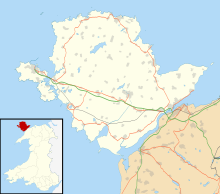
Anglesey Airport (Welsh: Maes Awyr Môn) (IATA: VLY, ICAO: EGOV) is an airport owned by the Isle of Anglesey County Council on land leased from the Defence Infrastructure Organisation. The airport is situated at Llanfair-yn-Neubwll in Anglesey, Wales. The leased site is part of RAF Valley.
- ^ "Airport information for EGOV" (PDF). UK Military AIP. Data current as of October 2006. Source: Ministry of Defence.
- ^ Airport information for EGOV at Great Circle Mapper. Source: DAFIF (effective October 2006).
Previous Page Next Page


