Our website is made possible by displaying online advertisements to our visitors.
Please consider supporting us by disabling your ad blocker.
Aniwa (island)
Aniwa | |
|---|---|
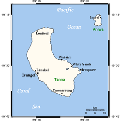
 Map of Tanna and Aniwa, with Aniwa at the top right | |
| Coordinates: 19°15′10″S 169°35′59″E / 19.25278°S 169.59972°E | |
| Country | |
| Province | Tafea Province |
| Area | |
• Total | 8 km2 (3 sq mi) |
| [1] | |
| Elevation | 42 m (138 ft) |
| Population (2009) | |
• Total | 341 |
| • Density | 43/km2 (110/sq mi) |
| Time zone | UTC+11 (VUT) |
Aniwa is a small island in the southernmost province of Tafea, Vanuatu.[2]
As a coral island (a raised coral atoll), it rises a mere 42 m above sea level. In the northwest is Itcharo (Tiaro) lagoon, which is open to the sea. The nearest large island is Tanna, about 24 km to the southwest.
- ^ "Vanuatu". Haos Blong Volkeno. Archived from the original on 8 August 2018. Retrieved 8 August 2018.
- ^ UNEP Islands Directory
Previous Page Next Page


