Our website is made possible by displaying online advertisements to our visitors.
Please consider supporting us by disabling your ad blocker.
Anne Beadell Highway
Anne Beadell Highway –South Australia | |
|---|---|
 | |
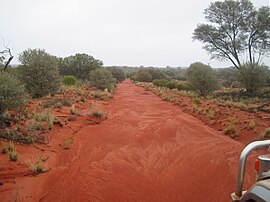
| The Anne Beadell Highway in South Australia. Heavy rain has washed out corrugations | |
 | |
| Coordinates | |
| General information | |
| Type | Track |
| Length | 1,325 km (823 mi)[1] |
| Major junctions | |
| West end | Laverton–Leonora Road Laverton, Western Australia |
| Connie Sue Highway | |
| East end | Coober Pedy, South Australia |
| Location(s) | |
| Region | Goldfields–Esperance (WA), Eyre Western, Far North (SA)[2] |
| Restrictions | |
| Permits | 4 required |
| Fuel supply | Ilkurlka 28°21′01″S 127°31′05″E / 28.350412°S 127.518027°E |
| Facilities | Ilkurlka |
| ---- | |
Anne Beadell Highway is an outback unsealed track linking Coober Pedy, South Australia, and Laverton, Western Australia, a total distance of 1,325 km (823 mi).[3] The track was surveyed and built by Len Beadell, Australian surveyor, who named it after his wife.[4]
The track passes through remote arid deserts and scrub territory of South Australia and Western Australia, which often have summer temperatures approaching 50 °C (122 °F). Sand dunes predominate for most of the track.
- ^ "Anne Beadell Highway" (Map). Google Maps. Retrieved 8 July 2022.
- ^ "Location SA Map viewer with regional layers". Government of South Australia. Retrieved 16 June 2022.
- ^ Hema, Maps (2005). Australia’s Great Desert Tracks SW Sheet (Map). Eight Mile Plains Queensland: Hema Maps. ISBN 1-86500-161-9.
- ^ Beadell, Len (1967). Bush Bashers. New Holland Publishers (Australia). ISBN 1-86436-734-2.
Previous Page Next Page


