Our website is made possible by displaying online advertisements to our visitors.
Please consider supporting us by disabling your ad blocker.
Antillia
| Antillia | |
|---|---|
| Portolan chart location | |
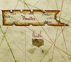
 Map of Albino de Canepa, dated 1489. Phantom island of Antillia, with its Seven Cities, on top; the smaller companion island of Roillo is below it | |
| In-universe information | |
| Type | Phantom island |
Antillia (or Antilia) is a phantom island that was reputed, during the 15th-century age of exploration, to lie in the Atlantic Ocean, far to the west of Portugal and Spain. The island also went by the name of Isle of Seven Cities (Ilha das Sete Cidades in Portuguese, Isla de las Siete Ciudades in Spanish).
It originates from an old Iberian legend, set during the Muslim conquest of Hispania c. 714. Seeking to flee from the Muslim conquerors, seven Christian Visigothic bishops embarked with their flocks on ships and set sail westwards into the Atlantic Ocean, eventually landing on an island (Antillia) where they founded seven settlements.
The island makes its first explicit appearance as a large rectangular island in the 1424 portolan chart of Zuane Pizzigano. Thereafter, it routinely appeared in most nautical charts of the 15th century. After 1492, when the north Atlantic Ocean began to be routinely sailed and became more accurately mapped, depictions of Antillia gradually disappeared. It nonetheless lent its name to the Spanish Antilles.
The routine appearance of such a large "Antillia" in 15th-century nautical charts has led to speculation that it might represent the American landmass,[1] and has fueled many theories of pre-Columbian trans-oceanic contact.
Previous Page Next Page


