Our website is made possible by displaying online advertisements to our visitors.
Please consider supporting us by disabling your ad blocker.
Apahida
Apahida | |
|---|---|
 | |
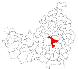
 Location in Cluj County | |
| Coordinates: 46°48′28″N 23°44′24″E / 46.80778°N 23.74000°E | |
| Country | Romania |
| County | Cluj |
| Established | 1263 |
| Subdivisions | Apahida, Bodrog, Câmpeneşti, Corpadea, Dezmir, Pata, Sânnicoară, Sub Coastă |
| Government | |
| • Mayor (2020–2024) | Grigore Fati[1] (PSD) |
Area | 106.02 km2 (40.93 sq mi) |
| Population (2021-12-01)[2] | 17,239 |
| • Density | 160/km2 (420/sq mi) |
| Time zone | EET/EEST (UTC+2/+3) |
| Postal code | 407035 |
| Area code | +40 x64 |
| Vehicle reg. | CJ |
| Website | www |
Apahida (Hungarian: Apahida; German: Bruckendorf; Latin: Pons Abbatis) is a commune in Cluj County, Transylvania, Romania. It is composed of eight villages: Apahida, Bodrog (Bodrog), Câmpenești, Corpadea (Kolozskorpád), Dezmir (Dezmér), Pata (Kolozspata), Sânnicoară (Szamosszentmiklós) and Sub Coastă (Telekfarka).
In 1889 and 1968 two rich archaeological treasures were discovered here. Apahida is an important road junction in Cluj County, as it links Cluj County with Mureș County, through DN16. It also provides quick access (approximately 20 minutes) from Cluj-Napoca to Băile Cojocna, famous for its salt waters and their curing properties.
- ^ "Results of the 2020 local elections". Central Electoral Bureau. Retrieved 11 June 2021.
- ^ "Populaţia rezidentă după grupa de vârstă, pe județe și municipii, orașe, comune, la 1 decembrie 2021" (XLS). National Institute of Statistics.
Previous Page Next Page


