Our website is made possible by displaying online advertisements to our visitors.
Please consider supporting us by disabling your ad blocker.
Appalachian Development Highway System
| Appalachian Development Highway System | |
|---|---|
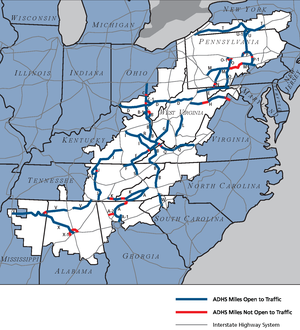
 Map of the Appalachian Development Highway System | |
| System information | |
| Maintained by state or local governments | |
| Length | 3,090 mi (4,970 km) |
| Formed | March 9, 1965 |

The Appalachian Development Highway System (ADHS) is a series of highway corridors in the Appalachia region of the eastern United States. The routes are designed as local and regional routes for improving economic development in the historically isolated region. It was established as part of the Appalachian Regional Development Act of 1965, and has been repeatedly supplemented by various federal and state legislative and regulatory actions. The system consists of a mixture of state, U.S., and Interstate routes. The routes are formally designated as "corridors" and assigned a letter. Signage of these corridors varies from place to place, but where signed are often done so with a distinctive blue-colored sign.
The Appalachian Regional Commission (ARC) forecast benefits of ADHS' completion by FY 2045 as the creation of 47,000 new jobs and $4.2 billion in gross regional product (GRP).[1]
Previous Page Next Page


