Our website is made possible by displaying online advertisements to our visitors.
Please consider supporting us by disabling your ad blocker.
Apple River (Illinois)
| Apple River | |
|---|---|
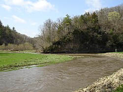
 The confluence of the South Fork Apple River and the Apple River within Apple River Canyon State Park | |
 | |
| Location | |
| Country | United States |
| State | Illinois, Wisconsin |
| Physical characteristics | |
| Source | |
| • location | East of Shullsburg, Lafayette County, Wisconsin |
| • coordinates | 42°33′51″N 90°09′47″W / 42.56417°N 90.16306°W |
| Mouth | Mississippi River |
• location | Northwest of Savanna, Carroll County, Illinois |
• coordinates | 42°10′35″N 90°14′36″W / 42.17639°N 90.24333°W |
| Length | 55 mi (89 km) |
| Discharge | |
| • location | Hanover, Illinois |
| • average | 199 cu/ft. per sec.[1] |
The Apple River is a tributary of the Mississippi River, about 55 miles (89 km) long,[2] in southwestern Wisconsin and northwestern Illinois in the United States. It rises in Lafayette County, Wisconsin, and flows for most of its length in Illinois, through Jo Daviess and Carroll Counties. Along its course it passes through Apple River Canyon State Park and the town of Hanover. It flows into the Mississippi River about 7 mi (11 km) northwest of Savanna.
In Jo Daviess County, it collects two short tributaries known as the West Fork Apple River and South Fork Apple River.
- ^ "USGS Current Conditions for USGS 05419000 APPLE RIVER NEAR HANOVER, IL".
- ^ U.S. Geological Survey. National Hydrography Dataset high-resolution flowline data. The National Map Archived 2012-03-29 at the Wayback Machine, accessed May 13, 2011
Previous Page Next Page


