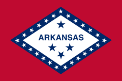
Our website is made possible by displaying online advertisements to our visitors.
Please consider supporting us by disabling your ad blocker.
Arkansas
Arkansas | |
|---|---|
| Nicknames: The Natural State (current) Land of Opportunity (former) | |
| Motto: Regnat populus (Latin: The People Rule) | |
| Anthem: "Arkansas", "Arkansas (You Run Deep in Me)", "Oh, Arkansas", and "The Arkansas Traveler" | |
 Map of the United States with Arkansas highlighted | |
| Country | United States |
| Before statehood | Arkansas Territory |
| Admitted to the Union | June 15, 1836 (25th) |
| Capital (and largest city) | Little Rock |
| Largest county or equivalent | Pulaski |
| Largest metro and urban areas | Central Arkansas |
| Government | |
| • Governor | Sarah Huckabee Sanders (R) |
| • Lieutenant governor | Leslie Rutledge (R) |
| Legislature | Arkansas General Assembly |
| • Upper house | Senate |
| • Lower house | House of Representatives |
| Judiciary | Arkansas Supreme Court |
| U.S. senators | John Boozman (R) Tom Cotton (R) |
| U.S. House delegation | 4 Republicans (list) |
| Area | |
• Total | 53,179 sq mi (137,732 km2) |
| • Land | 52,035 sq mi (134,771 km2) |
| • Water | 1,143 sq mi (2,961 km2) 2.15% |
| • Rank | 29th |
| Dimensions | |
| • Length | 240 mi (386 km) |
| • Width | 270 mi (435 km) |
| Elevation | 650 ft (200 m) |
| Highest elevation | 2,753 ft (839 m) |
| Lowest elevation | 55 ft (17 m) |
| Population (2020) | |
• Total | 3,011,524[5] |
| • Rank | 34th |
| • Density | 57.9/sq mi (22.4/km2) |
| • Rank | 34th |
| • Median household income | $49,500[6] |
| • Income rank | 48th |
| Demonym | Arkansan Arkansawyer Arkanite[7] |
| Language | |
| • Official language | English[8] |
| Time zone | UTC−06:00 (Central) |
| • Summer (DST) | UTC−05:00 (CDT) |
| USPS abbreviation | AR |
| ISO 3166 code | US-AR |
| Traditional abbreviation | Ark. |
| Latitude | 33° 00′ N to 36° 30′ N |
| Longitude | 89° 39′ W to 94° 37′ W |
| Website | arkansas |
| List of state symbols | |
|---|---|
 | |
 | |
| Living insignia | |
| Bird | Mockingbird |
| Butterfly | Diana fritillary |
| Flower | Apple blossom |
| Insect | Western honeybee |
| Mammal | White-tailed deer |
| Tree | Pine tree |
| Vegetable | South Arkansas vine ripe pink tomato |
| Inanimate insignia | |
| Beverage | Milk |
| Dance | Square dance |
| Food | Pecan |
| Gemstone | Diamond |
| Mineral | Quartz |
| Rock | Bauxite |
| Soil | Stuttgart |
| State route marker | |
 | |
| State quarter | |
 Released in 2003 | |
| Lists of United States state symbols | |
Arkansas (/ˈɑːrkənsɔː/ AR-kən-saw[c]) is a landlocked state in the West South Central region of the Southern United States.[9][10] It borders Missouri to the north, Tennessee and Mississippi to the east, Louisiana to the south, Texas to the southwest, and Oklahoma to the west. Its name derives from the Osage language, and refers to their relatives, the Quapaw people.[11] The state's diverse geography ranges from the mountainous regions of the Ozark and Ouachita Mountains, which make up the U.S. Interior Highlands, to the densely forested land in the south known as the Arkansas Timberlands, to the eastern lowlands along the Mississippi River and the Arkansas Delta.
Previously part of French Louisiana and the Louisiana Purchase, the Territory of Arkansas was admitted to the Union as the 25th state on June 15, 1836.[12] Much of the Delta had been developed for cotton plantations, and landowners there largely depended on enslaved African Americans' labor. In 1861, Arkansas seceded from the United States and joined the Confederate States of America during the American Civil War. On returning to the Union in 1868, Arkansas continued to suffer economically, due to its overreliance on the large-scale plantation economy. Cotton remained the leading commodity crop, and the cotton market declined. Because farmers and businessmen did not diversify and there was little industrial investment, the state fell behind in economic opportunity. In the late 19th century, the state instituted various Jim Crow laws to disenfranchise and segregate the African-American population. White interests dominated Arkansas's politics, with disenfranchisement of African Americans and refusal to reapportion the legislature; only after the federal legislation passed were more African Americans able to vote. During the civil rights movement of the 1950s and 1960s, Arkansas and particularly Little Rock were major battlegrounds for efforts to integrate schools. Following World War II in the 1940s, Arkansas began to diversify its economy and see prosperity. During the 1960s, the state became the base of the Walmart corporation, the world's largest company by revenue, headquartered in Bentonville.
Arkansas is the 29th largest by area and the 34th most populous state, with a population of just over three million at the 2020 census.[5] The capital and most populous city is Little Rock, in the central part of the state, a hub for transportation, business, culture, and government. The northwestern corner of the state, including the Fayetteville–Springdale–Rogers Metropolitan Area and Fort Smith metropolitan area, is a population, education, and economic center. The largest city in the state's eastern part is Jonesboro. The largest city in the state's southeastern part is Pine Bluff.
In the 21st century, Arkansas's economy is based on service industries, aircraft, poultry, steel, and tourism, along with important commodity crops of cotton, soybeans and rice. The state supports a network of public universities and colleges, including two major university systems: Arkansas State University System and University of Arkansas System. Arkansas's culture is observable in museums, theaters, novels, television shows, restaurants, and athletic venues across the state.
- ^ "Mag". NGS Data Sheet. National Geodetic Survey, National Oceanic and Atmospheric Administration, United States Department of Commerce. Retrieved October 20, 2011.
- ^ a b "Elevations and Distances in the United States". United States Geological Survey. 2001. Archived from the original on October 15, 2011. Retrieved October 21, 2011.
- ^ "Magazine Mountain". Geographic Names Information System. United States Geological Survey. Retrieved January 2, 2013.
- ^ "Signal Hill". Geographic Names Information System. United States Geological Survey. Retrieved January 2, 2013.
- ^ a b "2020 Census Apportionment Results". The United States Census Bureau. April 26, 2021. Retrieved April 27, 2021.
- ^ "US Census Bureau QuickFacts". Retrieved April 30, 2022.
- ^ Blevins 2009, p. 2.
- ^ "2020 Arkansas Code Title 1 - General Provisions Chapter 4 - State Symbols, Motto, Etc. § 1-4-117. Official language". Justia US Law. Retrieved April 27, 2023.
- ^ Jones, Daniel (1997) English Pronouncing Dictionary, 15th ed. Cambridge University Press. ISBN 0-521-45272-4.
- ^ "Census Regions and Divisions of the United States" (PDF). Geography Division, United States Census Bureau. Archived from the original (PDF) on January 20, 2013. Retrieved June 23, 2012.
- ^ Lyon, Owen (Autumn 1950). "The Trail of the Quapaw". Arkansas Historical Quarterly. 9 (3): 206–7. doi:10.2307/40017228. ISSN 0004-1823. JSTOR 40017228.
- ^ Cash, Marie (December 1943). "Arkansas Achieves Statehood". Arkansas Historical Quarterly. 2 (4): 292–308. doi:10.2307/40018776. JSTOR 40018776.
Cite error: There are <ref group=lower-alpha> tags or {{efn}} templates on this page, but the references will not show without a {{reflist|group=lower-alpha}} template or {{notelist}} template (see the help page).
Previous Page Next Page


