Our website is made possible by displaying online advertisements to our visitors.
Please consider supporting us by disabling your ad blocker.
Arwal district
Arwal district | |
|---|---|
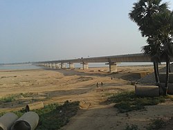
 Son River near Arwal | |
 Location of Arwal district in Bihar | |
| Country | |
| State | |
| Division | Magadh |
| Headquarters | Arwal |
| Government | |
| • Lok Sabha constituencies | Jahanabad |
| • Vidhan Sabha constituencies | Arwal and Kurtha |
| Area | |
• Total | 638 km2 (246 sq mi) |
| Population (2011) | |
• Total | 700,843 |
| • Density | 1,100/km2 (2,800/sq mi) |
| • Urban | 51,849 |
| Demographics | |
| • Literacy | 67.44 per cent |
| • Sex ratio | 928 |
| Time zone | UTC+05:30 (IST) |
| PIN Code | |
| Major highways | NH 98 |
| HDI (2016) | |
| Website | arwal |
Arwal district is one of the thirty-eight districts of Bihar state, India, and Arwal town is the administrative headquarters of this district. It was earlier part of Jehanabad district.
As of 2001 it is the third least populous district of Bihar (out of 38), after Sheikhpura and Sheohar.[2] Arwal District is very small district of Bihar. Most of people are engaged in primary sector.
- ^ "Development of Human Development Index at District Level for EAG States". March 2016. Retrieved 18 February 2022.
- ^ "District Census Handbook: Arwal" (PDF). Census of India. Registrar General and Census Commissioner of India. 2011.
Previous Page Next Page


