Our website is made possible by displaying online advertisements to our visitors.
Please consider supporting us by disabling your ad blocker.
Ashland, Pennsylvania
Ashland, Pennsylvania | |
|---|---|
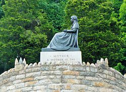
 Mothers' Memorial has been placed on the National Register of Historic Places | |
| Nickname: Black Diamonds | |
| Motto: Preserving Anthracite's Legacy | |
 | |
| Coordinates: 40°46′54″N 76°20′40″W / 40.78167°N 76.34444°W | |
| Country | United States |
| State | Pennsylvania |
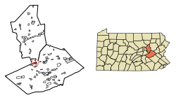
| Counties | Schuylkill / Columbia |
| Settled | 1820 |
| Laid out | 1847 |
| Incorporated | 1857 |
| Government | |
| • Type | Borough Council |
| • Mayor | Daniel Weikel |
| Area | |
• Total | 1.66 sq mi (4.29 km2) |
| • Land | 1.66 sq mi (4.29 km2) |
| • Water | 0.00 sq mi (0.00 km2) |
| Elevation | 980 ft (300 m) |
| Population | |
• Total | 2,471 |
| • Density | 1,490.35/sq mi (575.46/km2) |
| Time zone | UTC-5 (Eastern (EST)) |
| • Summer (DST) | UTC-4 (EDT) |
| ZIP Code | 17921 |
| Area codes | 570 and 272 |
| FIPS code | 42-03264 |
| Website | ashlandborough |

Ashland is a borough in Schuylkill County in the U.S. state of Pennsylvania, 15 miles (24 km) northwest of Pottsville. It is part of Northeastern Pennsylvania. A small part of the borough also lies in Columbia County, although all of the population resided in the Schuylkill County portion as of the 2020 census. The borough lies in the anthracite coal region of eastern Pennsylvania. Settled in 1850, Ashland was incorporated in 1857, and was named for Henry Clay's estate near Lexington, Kentucky. The population in 1900 was 6,438, and in 1940, 7,045, but had dropped to 2,471 at the 2020 census.[3]
It is the location of Pioneer Tunnel, a tourist attraction featuring a tour of a coal mine on mine cars and a separate 3 ft 6 in (1,067 mm) narrow gauge steam train ride.[4][5]
- ^ "ArcGIS REST Services Directory". United States Census Bureau. Retrieved October 12, 2022.
- ^ Cite error: The named reference
USCensusDecennial2020CenPopScriptOnlywas invoked but never defined (see the help page). - ^ "Geographic Identifiers: 2010 Census Summary File 1 (G001): Ashland borough, Pennsylvania". U.S. Census Bureau, American Factfinder. 2010. Archived from the original on February 13, 2020. Retrieved May 19, 2015.
- ^ "Surviving Steam Locomotive Search for "Pioneer Tunnel"". Steam Locomotive dot Com. June 26, 2015. Retrieved June 26, 2015.
- ^ "Welcome to Pioneer Tunnel". Pioneer Tunnel Coal Mine & Steam Trail. August 2, 2014. Retrieved August 2, 2014.
Previous Page Next Page
آشلاند (بنسيلفانيا) Arabic Ашланд Bulgarian Ashland (Pennsilvània) Catalan Эшленд (Пенсильвани) CE Ashland (lungsod sa Tinipong Bansa, Pennsylvania) CEB Ashland, Pennsylvania CY Ashland (Schuylkill County, Pennsylvania) German Ashland (Pensilvania) Spanish Ashland (Pennsylvania) EU Ashland (Pennsylvanie) French


